Flood watch through Saturday
Jefferson County Alert: Flood Watch issued March 22 at 2:50PM EDT until March 25 at 2:00PM EDT by NWS Louisville KY * WHAT...Flooding caused by excessive rainfall is possible. * WHERE...Portions of southern Indiana and north central Kentucky. * WHEN...From Thursday evening through Saturday afternoon. * IMPACTS...Excessive runoff may result in flooding of rivers, creeks, streams, and other low-lying and flood-prone locations. * ADDITIONAL DETAILS... - Moderate to heavy rainfall is expected across southern Indiana and north central Kentucky Thursday night through Saturday. Rainfall amounts of 2 to 4 inches with locally higher amounts will be possible. Southern Indiana is mostly likely to see the highest rainfall totals and greatest flood risk according to the latest forecast data. - http://www.weather.gov/safety/flood You should monitor later forecasts and be alert for possible Flood Warnings. Those living in areas prone to flooding should be prepared to take action should flooding develop.
 USPS Reminds Public Fireworks Don't Belong in the Mail
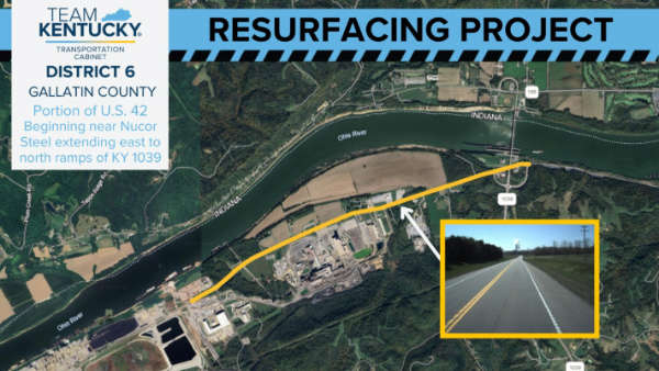 Resurfacing Project on U.S. 42 in Gallatin County
 JD Shelburne to Debut at the Grand Ole Opry