Makes a full circle
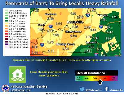
Increased rainfall coverage and intensity are expected Tuesday into Wednesday as the remnants of Tropical Storm Barry impact the Ohio Valley.
Heavy rain will be the primary hazard, with rainfall totals of 1 to 3 inches possible. Any flooding concerns will depend on where and how quickly that rainfall occurs.
Barry is making a rare full circle as it began as a Low Pressure System in the Midwest last Sunday.
This system will just bring heavy amounts of rain and not the wind event like Ike did back in September of 2008.
 Kentucky's Attorney General Joins Trump Administration to Keep Politics Out of Food Benefits Program
 LEADERSHIP JEFFERSON COUNTY ACCEPTING APPLICANTS FOR 2027 CLASS
 FSSA To Text HIP Members about HIP Work Requirements